赵卿 |

|
|
|
|
10 访问 |
个人资料
教育经历2010年6月,获香港中文大学博士学位 2006年6月,获武汉大学理学硕士学位 2004年6月,获中南大学工学学士学位 工作经历任职简况 2019/9-2020/12,华东师范大学地球科学学部崇明高峰,特聘教授 2014/1-至今,华东师范大学,地理科学学院,副教授 2010/7-2013/12,华东师范大学,资源与环境科学学院地理学系,讲师 2007/1-2010/6,香港中文大学,太空与地球信息科学研究所卫星遥感地面接收站,研究助理 研修与外访 2010/11 – 2010/12,香港中文大学太空与地球信息科学研究所合作研究 2009/07 – 2009/10,美国斯坦福大学地球物理系访问研究 个人简介赵卿,华东师范大学地理科学学院暨地理信息科学教育部重点实验室副教授。2009年赴美国斯坦福大学地球物理学院访问。2010年毕业于香港中文大学获地球信息科学专业博士学位。受聘华东师范大学以来,承担了国家自然科学基金项目,上海市自然科学基金项目,中欧科技合作“龙计划”三期、四期、五期项目和德国空间局新一代高分辨率合成孔径雷达卫星科学数据共享计划项目。参加了2017国家重点研发计划项目,政府间国际科技创新合作重点专项“金砖国家城市公共安全的地理大数据应用研究”,该项目中期考核为优秀;参加了上海市科委2010年世博专项基金“世博后上海空气质量跟踪监测与应用研究”,气溶胶时空分布特征研究专题负责人;参加了上海市科委2013年重点支撑课题“东滩生态城与绿色养老社区生态建设关键技术研究”。2016年获得了科技部国家遥感中心和欧洲空间局共同颁发的龙计划三期项目突出贡献奖,表彰在2012-2016项目成功实施取得的丰硕成果。2017年获得第四届全国高校GIS青年教师讲课竞赛一等奖。2018年获得华东师范大学第十二届青年教师教学比赛二等奖。在国际刊物和学术会议上发表学术论文50余篇。近三年来研究成果已发表在相关领域的权威国际期刊ISPRS Journal of Photogrammetry and Remote Sensing(一区),International Journal of Applied Earth Observation and Geoinformation(一区),Geospatial Information Science(一区),Remote Sensing(二区),和 IEEE Journal of Selected Topics in Applied Earth Observations and(二区)上。 社会兼职中国海外地理信息系统协会(CPGIS)会员 中国地理学会会员 IEEE会员 IEEE Geoscience and Remote Sensing Society 会员 Scientific Committee member for IGARSS 2023 IEEE Young Professionals 会员 杂志审稿人:IEEE Journal of Selected Topics in Applied Earth Observations and Remote Sensing,IEEE Geoscience and Remote Sensing Letters,IEEE Transactions on Geoscience and Remote Sensing,Remote Sensing,Remote Sensing Letters,Acta Oceanologica Sinica,Urban Climate,IEEE Access,海洋学报,国土资源遥感 2020-2022担任上海市第一次自然灾害综合风险普查领导小组办公室技术组专家 2021-2022担任金山区第一次自然灾害综合风险普查领导小组办公室工作组组长 2021-2022受聘为上海市第一次自然灾害综合风险普查领导小组办公室评估应用组副组长 研究方向
招生与培养1名研究生获华东师范大学“焕庸地理大讲堂”学术作品竞赛一等奖 3名研究生毕业论文获评为地球科学学部优秀硕士学位论文 1名研究毕业论文获评为华东师范大学优秀硕士学位论文 5名研究生获中国研究生数学建模竞赛一等奖 开授课程卫星遥感数据处理与应用 地理科学文献阅读与写作 地理信息科学综合实习 科研项目承担的主要研究项目 国家自然科学基金项目,2019-2021 上海市科学基金面上项目,2018-2021 华东师范大学科研创新基金项目,2019 地方委托项目,长时序InSAR监测新成陆区地面沉降研究,2015-2016 国家外专局高端外国专家项目,2014-2016 上海市自然科学基金项目,利用星载合成孔径雷达监测上海临港新城地表沉降研究,2013-2016. 德国空间局新一代高分辨率合成孔径雷达卫星科学数据共享计划项目,PSI detection of residual settlement in Yangze River Delta,2013-2015. 华东师范大学地理信息科学教育部重点实验室主任基金,2013-2015 华东师范大学科研创新基金,2012-2013 上海市城市化生态过程与生态恢复重点实验室开放基金,2012-2013 参加的主要研究项目 国家重点研发计划,金砖国家城市公共安全的地理大数据应用研究,2017-2020.(中期考核优秀)项目骨干 上海市科委重点支撑课题(2014-2016) 上海市科委世博专项基金(2010-2013) 国际合作项目成果: 欧洲合作伙伴Antonio Pepe研究员获聘国家外专局高端外国专家 收到科学技术部国家遥感中心感谢函“2018年度我国参与的“龙计划”相关工作已圆满结束并取得了丰硕成果,得到中欧双方的高度评价。贵单位赵卿同志作为“龙计划”四期项目的中方专家,对“龙计划”四期合作取得实质性进展做出了重要贡献。现特发此函,谨对贵单位给予的大力支持表示衷心的感谢!” 近几年承担的国际合作项目: 中国-欧洲空间局“龙计划5”合作项目(2020.6-2024.6) 中国-欧洲空间局“龙计划4”合作项目(2016.6-2020.6) 中国-欧洲空间局“龙计划3”合作项目(2012.6-2016.6) 国内外学术交流 2019.10.19 主持2019中国地理信息科学理论与方法学术年会城市雷达遥感大数据分析与应用分会场并做口头报告“基于多卫星平台MT-InSAR融合的新成陆区超长时序地面沉降研究” 2019.5.20 - 2019.5.22 参加俄罗斯圣彼得堡国家重点研发计划政府间合作项目金砖国家城市公共安全的地理大数据应用研究项目成果中期汇报会 2019.5.22 - 2019.5.23 参加华东师范大学和意大利罗马大学学术交流研讨会,并做口头报告 2018.5.13 - 2018.5.18 参加俄罗斯圣彼得堡国家重点研发计划政府间合作项目金砖国家城市公共安全的地理大数据应用研究项目成果交流会 2018.6.19 - 2018.6.22参加西安召开的2018年“龙计划”四期中期成果国际学术研讨会并做口头报告 2018.9.28 参加了第二届华东师范大学地理科学学院和澳大利亚昆士兰大学地球科学与环境学院联合研讨会,并做口头报告 2013.6.3 - 2013.6.7参加在意大利巴勒莫市召开的“龙计划”三期研讨会 2013.4 参加在武夷山举办的吕宋海峡海洋中尺度过程国际学术研讨会 2012.10应西安电子科技大学智能感知与图像理解教育部重点实验室邀请做专题学术报告 2012.10 参加国家海洋环境监测中心召开的海洋环境监测高技术研讨会并做专题学术报告 2012.8.12 - 2012.8.16在新加坡召开的AOGS-AGU (WPGM) Joint Assembly做口头报告 2012.7.15 - 2012.7.22参加联合国教科文组织(UNESCO)培训研究中心举办的卫星遥感系列讲座 2012.6.25 - 2012.6.29在北京召开的“龙计划”二期总结研讨会暨三期启动会做口头报告 2011.11.11 应中国科学院电子学研究所邀请做专题学术报告 2011年10月应上海海洋大学邀请参加微波遥感海岸带及近海风能研讨会 2011年6月参加在上海举办的19th International Conference on Geoinformatics 学术成果ResearcherID: K-8844-2014 在国际刊物和国际学术会议上发表学术论文50余篇。
[27]Zhao, Q., A. Pepe, W. Gao, Z. Lu, M. Bonano, M.L. He, J. Wang, X. Tang, A DInSAR Investigation of the ground settlement time evolution of ocean-reclaimed lands in Shanghai, IEEE Journal of Selected Topics in Applied Earth Observations and Remote Sensing, 8(4):1763-1781, 2015(SCI)[26]Zhai, T., Q. Zhao*, W. Gao, R. Shi, W. Xiang, H. Huang, C. Zhang, Analysis of spatio-temporal variability of aerosol optical depth with empirical orthogonal functions in the Changjiang River Delta, China,Frontiers of Earth Science, 9(1):1-12, 2015 (SCI)
[25] Zeni, G., A. Pepe, Q. Zhao*, M. Bonano, W. Gao, X. Li, X. Ding, A Differenital SAR Interferometry (DINSAR)Investigation of the deformation affecting the coastal reclaimed areas of the Shanghai Megacity, in IGARSS 2014, Quebec, Canada, July 13-18, 2014 [24]Zhao, Q.*, W. Gao, W. Xiang, R. Shi, C. Liu, T. Zhai, H. Huang, L. Gumley, K.Strabala, Analysis of air quality variability in Shanghai using AOD and API data in recent decade, Frontiers of Earth Science, 7(2):159-168, 2013 (SCI)
[23]Zheng, Q., Q. Zhao*, Y. Yuan, X. Liu, J. Hu, X. Liu, L. Yin, X. Ye, Shear-flow induced secondary circulation in parallel underwater topographic corrugation, Journal of Ocean University of China, 11(4): 427-435, 2012 (SCI)
[22]Zheng, Q., B. Holt, X. Li, X. Liu, Q. Zhao, Y. Yuan, X. Yang, Deep-water seamount wakes on SEASAT SAR image in the Gulf, Geophysical Research Letters, 39:L16604, 2012 (SCI)[21]Zhao, Q.*, H. Lin, W. Gao, H. Zebker, A. Chen, K. Yeung, 2011. InSAR Detection of Residual Settlement of an Ocean Reclaimation engineering project: a case study of Hong Kong International Airport, Journal of Oceanography, 67: 415-426. (SCI)
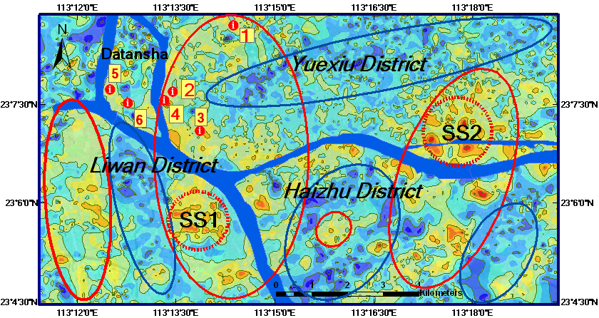
[20]Zheng, Q., Q. Zhao, N. Walker, C. Li, 2010. Oil spil in the Gulf of Mexico and spiral vortex, Acta Oceanologica Sinica, 29(4): 1-2. (SCI)[19]Zhao, Q.*, H. Lin, L. Jiang, F. Chen, and S. Cheng, 2009. A study of ground deformation in Guangzhou urban area with Persistent Scatterer Interferometry, Sensors, 9(1): 503-518. (SCI)
[18]Lin, H., F. Chen, and Q. Zhao, 2009. Land deformation monitoring using coherent target-neighborhood networking method combined with polarimetric information, a case study of Shanghai, China, International Journal of Remote Sensing, 32(9): 2395-2407. (SCI)[17]Jiang, L., H. Lin, Q. Zhao, 2010. Spatial and temporal deformation characteristics of marine alluvial deposits due to land reclamation: implications from InSAR observation and geotechnical estimate, Earth Surface Processes and Landforms, 35, 331-343. (SCI)[16]Lin, H., L. Jiang, and Q. Zhao, 2008. Urban land subsidence monitoring with Differential InSAR technique, City pioneer, 2008(04): 39-46.[15]Liao, M., X. Tian, and Q. Zhao, 2007. Missions and applications of TerraSAR-X/TanDEM-X, Journal of Geomatics, 32(2):44-46.
|