|
李响职称: 直属机构: 地理科学学院 学科: |
|
|
|
10 访问 |
相关教师 |
个人资料
教育经历2004: Ph.D. in Geography, Supervisor Prof. Hui Lin, The Chinese University of Hong Kong 2000: M.Sc. in Cartography and GIS, Supervisor Prof. Manchun Li, Nanjing University 1997: B.Sc. in Economic Geography and Urban Planning, Nanjing University 1997: Minor in Computer Application, Nanjing University 工作经历Aug. 2014 - Aug. 2015: Visiting Scholar, The Department of Geography, Ohio State University, Columbus, OH, USA Jul. 2012 - Aug. 2012: Visiting Scholar, The Department of Geography and Resource Management, The Chinese University of Hong Kong, Hong Kong Aug. 2011 - now:Professor, East China Normal University, China Jan. 2007 - Jul. 2011: Associate Professor, East China Normal University, China Nov. 2009: Visiting Scholar, GIS Research Lab, Naval Academy Research Institute, France Jul. 2009 - Sep. 2009: Visiting Scholar, Institute of Space and Earth Information Science, The Chinese University of Hong Kong, Hong Kong Jul. 2007 - Oct. 2007: Visiting Scholar, Institute of Space and Earth Information Science, The Chinese University of Hong Kong, Hong Kong Sep. 2005 - Dec. 2006: Postdoctoral Fellow, Dept. of Earth Sciences, University of Memphis, US Jan. 2005 - Jul. 2005: Postdoctoral Fellow, GIS Research Lab, Naval Academy Research Institute, France 2002 - 2004: Teaching Assistant, The Department of Geography and Resource Management, The Chinese University of Hong Kong, Hong Kong 2001 - 2002: Research Assistant, The Joint Laboratory for GeoInformation Science, The Chinese University of Hong Kong, Hong Kong 2000 - 2001: GIS Software Engineer, Newland Co. Ltd., Fuzhou, China 1997 - 2000: Teaching Assistant, The Department of Urban and Resource Management, Nanjing University, China 个人简介个人微信公众号“大数据攻城狮”,欢迎关注!
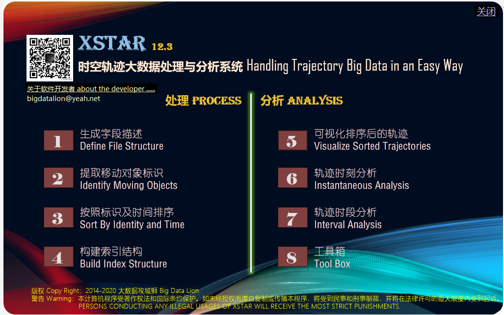
先后于南京大学获得学士及硕士学位,于香港中文大学获得博士学位,曾于法国及美国从事博士后研究工作,目前任职于华东师范大学地理科学学院暨地理信息科学教育部重点实验室,受聘为教授,博士生导师,同时担任低空经济空间智能技术研究中心主任、地理信息科学教育部重点实验室副主任、城市空间优化与智能交通研究工作室负责人,IJGIS编委。自2012年起,担任上海市闵行区政协委员,自2016年起,担任民进华东师范大学副主委、民进上海市委城市治理专委会副主委。 其学术成绩主要集中在以下两个研究方向“时空轨迹大数据处理及应用”与“空间智能分析算法”,主持相关省部级以上研究课题20余项,发表相关学术论文近200篇,出版相关学术专著4部。在时空轨迹大数据处理及应用领域,开发了国内外首套专用于时空轨迹数据管理与应用的软件工具XSTAR,截止2023年底,下载量超过8000次。在空间智能分析算法方面,关注于跨学科研究与跨领域应用的各种空间智能问题,充分发挥人工智能的自动时空信息采集技术、基于地理信息系统平台、构建领域相关的应用模型、实现现实问题的有效解决,在生产安防、环境保护、城市规划、交通管理、公安监控等方面有多项落地的应用。更详细介绍可参见其微信公众号“大数据攻城狮”。 2022年春,上海疫情期间,快速反应,免费志愿研发用于社区内部保供物资快速配送物流系统,在近二百个小区中得到应用,被国家和地方数十个媒体所报道,详情可于互联网中搜索“送货地图”。 (更新于2024-10-1) 当前研究兴趣 集成深度强化学习的空间优化 视频或影像数据中时空信息的智能提取与建模 时空大数据的处理与应用 欢迎青年学生学者与我联系(xli@geo.ecnu.edu.cn),攻读硕士博士研究生或合作开展博士后研究! 我们的原则是:
社会兼职【社会职务】 上海市闵行区政协委员(2012年1月至今) 民进华东师范大学副主委(2016年8月至今) 民进上海市委城市治理专委会副主任(2020年7月至今) 【行政职务】 华东师范大学低空经济空间智能技术研究中心主任(2024年9月至今) 华东师范大学地理信息科学教育部重点实验室副主任(2019年3月至今) 【学术协会职务】 成员,中国国际创新大赛专家库(2025年8月至今) 委员,中国卫星导航定位协会成立低空经济工作委员会(2025年5月至今) 委员,中国测绘学会低空开发与利用工作委员会(2025年4月至今) 委员,中国地理学会空间综合人文社会科学工作委员会(2023年10月至今) 委员,世界交通运输大会“交通大数据时空分析与应用”技术委员会(2023年4月至今) 委员,中国测绘学会智慧城市工作委员会(2023年1月至今) 委员,中国地理信息系统产业协会就业指导工作委员会(2022年4月至今) 委员,ACM SIGSPAITAL中国分委员会,(2021年1月至今) 理事,中国地理信息系统产业协会,(2021年10月至今) 副主任委员,中国自然资源学会教育工作委员会(2018年11月至今) 委员,中国地理信息系统产业协会理论与方法工作委员会,(2017年3月至今) 【期刊编委】 The Open Geography Journal (since 2007) Journal of Geographic Information System (since 2010) Frontiers of Earth Science (since 2012) International Journal of Spatial, Temporal and Multimedia Information Systems (since 2013) International Journal of Geographical Information Science (since 2017) 地球信息科学学报 (自从2026) 【期刊审稿人】 Transportation Research Part C: Emerging Technologies (since 2007), Acta Geodaetica et Cartographica Sinica (since 2007), Geo-Information Science (since 2008), International Journal of Geographical Information Science (since 2008), Transactions on Intelligent Transportation Systems (since 2008), Annals of GIS (since 2009), Computers, Environment and Urban Systems (since 2010), International Journal of Digital Earth (since 2012), International Geocarto (since 2014), Open Journal of Databases (since 2014), Transactions in GIS (since 2014), Journal of Spatial Science (since 2014), International Journal of Spatial, Temporal and Multimedia Information Systems (since 2015), Applied Geography (since 2020), Journal of Geographical Sciences (since 2020), ...... 【学术会议组织】 PC Chair,SpatialDI 2023,江西 Publicity Chair, The 21th IEEE Conference on Mobile Data Management, Versailles, France, June 30 - July 3, 2020 会议秘书组成员,2019 中国地理信息科学理论与方法学术年会,2019年10月18日-20日 论坛秘书长,第九届空间综合人文学与社会科学国际论坛,2018年6月23-25日,上海 PC member, SpatialDI 2022,2022年 PC member, The 10th International Conference on Geographic Information Science, (GIScience'18), 28-31 August, 2018, Melbourne, Australia PC member, The 8th International Symposium “Information Fusion and Intelligent Geographical Information Systems 2017” (IF&IGIS’17), Shanghai, China Conference chair, 15th International Symposium on Web and Wireless Geographical Information Systems W2GIS 2017, May 8-9, 2017, Shanghai, China PC member,The 24th International Conference on GeoInformatics, 2016, Galway, Ireland. PC member,The 23th International Conference on GeoInformatics, 2015, Wuhan, China. PC member,The 22th International Conference on GeoInformatics, 2014, Kaohsiung, Taiwan. PC member,The Third International Workshop on Spatial Information Modeling, Management and Mining (SIM3), April 21-24, 2014, Bali, Indonesia. PC member,The 8th International Conference on Geographic Information Science, September 24 to 26, 2014, Vienna University of Technology, Austria. PC member,The 21th International Conference on GeoInformatics, 2013, kaifeng, China. Scientific advisory board member,Open Source Geospatial Research and Education Symposium(OGRS2012), October 24-26, 2012, Yverdon-les-Bains, Switzerland. PC member,The 7th International Conference on Geographic Information Science, September 19 to 21, 2012, Ohio, USA. PC member,The 20th International Conference on GeoInformatics, 2012, Hong Kong, China. Committee member, Theory and Methodology Group,China Association for Geographic Information System(CAGIS), since 2012. PC member,The Second International Workshop on Spatial Information Modeling, Management and Mining(SIM3), part of DASFAA2012, April 15-18, 2012, Busan, South Korea Committee member, Foresight Committee of Key Fields (urban safety and hazard mitigation) in Science and Technology Development, Shanghai, Sep. 2011-Mar. 2012. Track committee member,The 27th Annual ACM Symposium on Applied Computing, Italy, 2010 Secretary general,The 19th International Conference on GeoInformatics, Shanghai, China, 2011 Member,IEEE,IEEE GRSS,CPGIS, since 2010 BOD member ofThe Association of Chinese Professionals in GIS(CPGIS), 2010-2011 PC member,The International Conference on Remote Sensing, Environment and Transportation Engineering(RSETE 2011), Nanjing, China, 2011 PC member, The First International Workshop on Spatial Information Modeling, Management and Mining (SIM3), part ofDASFAA2011, Hong Kong, China, 2011 Track committee member,The 26th Annual ACM Symposium on Applied Computing, Taiwan, 2010 Track committee member,The 25th Annual ACM Symposium on Applied Computing, Switzerland, 2010 PC member,International Workshop on GIS for Transportation, Wuhan, China, 2009 Invited reviewer,The 2009 International Conference on Web Information Systems and Mining (WISM’09) and the 2009 International Conference on Artificial Intelligence and Computational Intelligence (AICI'09), Shanghai, China, 2009 Reviewing committee member,The International Opensource Geospatial Research Symposium, France, 2009 PC member,Web and Wireless GIS 2009, Ireland, 2009 Symposium chair ofWeb and Wireless GIS 2008, Shanghai, China, 2008 BOD member ofThe Association of Chinese Professionals in GIS(CPGIS), 2002-2004 BOD member ofChina Association for Geographic Information System(CAGIS), since 2007 Technical committee member ofChina Association of GIS for Transportation, since 2007 Track committee member ofThe 24th Annual ACM Symposium on Applied Computing, USA, 2009 Track committee member ofThe 23rd Annual ACM Symposium on Applied Computing, Brazil, 2008 Affiliate member of the Graduate Faculty,Dept. of Earth Sciences, University of Memphis, US, 2005-2008 Member ofNorth America Chinese Transportation Association(NACOTA), since 2004 Member ofThe Association of American Geographers(AAG), since 2005 研究方向
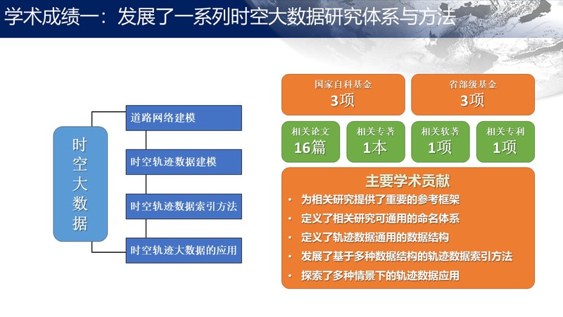
招生与培养开授课程主讲:本科生,程序设计(C#),华东师范大学,自从2020 主讲:本科生,地理信息系统底层开发教程,华东师范大学,自从2016 主讲:本科生,地理科学研究方法与实践,华东师范大学,2018-2019 组织讲授:研究室,地理信息科学,华东师范大学,自从2014 主讲:本科生,空间数据分析与建模,华东师范大学,2009-2018 主讲:本科生,地理信息系统高级教程,华东师范大学,2007-20015 Instructor,Spatial Data Analysis and Modeling, East China Normal University, Since 2009 Instructor,Advanced GIS, East China Normal University, 2007-2015 Instructor, ESCI/PLAN-4515/6515:Geographic Information Science, The University of Memphis, Fall 2006 Instructor, ESCI/PLAN-1401-504:Intro/Cultural Geography, The University of Memphis, Fall 2007 Instructor, GEOG-4515/6515:Geographic Information Science, The University of Memphis, Summer 2006 Instructor, GEOG/PLAN-4515/6515:Geographic Information Science, The University of Memphis, Spring 2006 Teaching Assistant,Computer Cartography,Geographical Information Systems,Statistical Analysis in Geography,Understanding China through Travel, The Chinese University of Hong Kong, 2002-2004 Teaching Assistant,Computer Programming with Language C. Nanjing University, 1997-2000 科研项目2025年12月,科技成果转化,“一种基于离散点密度与全局规划的无人机巡检路径规划方法,专利申请号:202210041817.8” 2025年12月至2026年12月,中国测绘科学研究院,“导助航信息应用与服务智能监控与可视化分析系统” 2022年8月至2024年7月,重庆自然科学基金面上项目,“基于多源大数据及智能分析的城市职住空间平衡现状分析与趋势预测”,编号:CSTB2022NSCQ-MSX2069 8/2019-7/2022 Co-Investigator (PI: Prof. CAI Yongli), 教育部哲学社会科学研究重大课题, “大数据驱动下自然资源生态安全预测预警预案(负责课题五:自然资源生态安全预测预警预案大数据共享与云协作平台构建)”, Ref. No. 19JZD023. (RMB 800,000) 1/2018-12/2021 Principal Investigator, 国家自然科学基金面上项目, “基于可控时空立方体的车辆轨迹大数据检索方法研究, Ref. No. 41771410. (RMB 748,000) 1/2014-12/2016 Principal Investigator, 教育部博士点博导基金,Ministry of Education Foundation for Doctoral Supervisors in Doctoral Program, “Key Technology on Evaluation of Traffic Intersection with Unmanned Aerial Vehicle, Ref. No. 20130076110014. (RMB 120,000) 1/2013-6/2015 Co-Investigator (PI: Prof. YANG Liao), 863项目,华东师范大学课题负责人,The National High Technology Research and Development Program of China Integrated Spatial Analysis, Simulation, and Decision based on Comprehensive Spatio-temporal Data in Urban Area, Ref. No. 2013AA122302. (RMB 9,200,000) 1/2013-12/2013 Principal Investigator, 华东师范大学,校内创新基金,Innovation Research Grant of East China Normal University, Environment surveillance and emergence evacuation for integrated indoor and outdoor space . (RMB 100,000) 1/2013-12/2016 Principal Investigator, 国家自然科学基金面上项目, National Natural Science Foundation of China, Traveler-oriented path travel time prediction with numerous taxi trajectories in highly urbanized area, Ref. No. 41271441. (RMB 750,000) 7/2011-7/2012 Principal Investigator, Grant from China Data Center, University of Michigan, “Virtual Environment Project”. (USD 5,000) 1/2012-6/2013 Principal Investigator, Grant from Shanghai Key Lab for Urban Ecology and Sustainability, “Estimate the volume of vehicle exhaust in road network with a large number of vehicle trajectory data”, Ref. No. SHUES2011A01. (RMB 50,000) 6/2011-5/2013 Principal Investigator, Director Grant of Key Lab of GIScience, Ministry of Education, “Traffic Flow Forecasting Based on Vehicle Trajectory Data”, Ref. No. KLGIS2011C01. (RMB 50,000) 4/2011-3/2014 Principal Investigator, Natural Science Foundation of Shanghai, “Vehicle Trajectory-oriented Spatial Data Query Language”, Ref. No. 11ZR1410100. (RMB 100,000) 8/2010-8/2011 Principal Investigator, East China University of Science and Technology, “Study on Urban Development Indicator Systems”. (RMB 30,000) 1/2009-12/2010 Co-Investigator, (PI: Prof. LIN Hui) Hong Kong RGC Project Modeling Pedestrian Evacuation using a Geo-referenced Multi-agent Approach: Taking Hong Kong's Fireworks Show as a Sample Case, Ref. No. 405608. (HKD 290,000) 1/2009-12/2011Principal Investigator,Scientific Research Foundation for the Returned Overseas Chinese Scholars, State Education Ministry, Network-based Spatio-temporal Data Indexing and Query Language , (RMB25,000) 10/2007-9/2009 Principal Investigator, Shanghai Pujiang Program, Key techniques of applying GIS to emergency services, Ref. No. 07PJ14035. (RMB250,000) 1/2008-12/2010 Principal Investigator, National Natural Science Foundation of China, Data query language and data mining for trajectories of vehicles moving in a road network, Ref. No. 40701142. (RMB190,000) 1/2008-12/2011 Co-Investigator, (PI: Prof. YU Lizhong and Prof. XU Shiyuan) National Natural Science Foundation of China, Scenario-based natural hazard analysis for coastal cities, Ref. No. 40730526. (RMB1,900,000) 1/2008-12/2010 Co-Investigator, (PI: Prof. ZHENG Xiangmin) National Science Fund for Fostering Talents in Basic Science, Science and research training program in geography, Ref. No. J0730534. (RMB1,800,000) 1/2008-12/2010 Principal Investigator, Ministry of Education Foundation for Junior Faculty in Doctoral Program, Spatial modeling for distributed sensors in micro-environment, Ref. No. 20070269031. (RMB36,000) 1/2008-12/2008 Principal Investigator, Chinese Academy of Surveying and Mapping, “Applying GIS to emergency services”. (RMB 100,000) 10/2007-9/2009 Co-Investigator, (PI: Prof. YU Lizhong) Shanghai S&T Foundation, A decision-support system for digital Chongming Island, Ref. No. 07DZ12037. (RMB4,000,000) 09/2005-12/2006 GIS-basedhazard mitigation planand database 04/2005-07/2005Spatial data mining: extending the capability of decision trees to spatial data 02/2002-04/2005GIS-T applications: How to efficiently manage and apply real-time traffic data with GIS technologies 02/2002-02/2005Moving objectdata management, analysis, and application in transportation 10/2001-02/2002Urban simulation,Virtual Geography Environment: building geometrical, physical, and behavioral models of geo-entities with GIS, VR, and Internet technologies 09/1998-07/2000 GIS-basedland price evaluation 09/1999-07/2000Web-based GIS. GIS data model, spatial analysis, and database 06/1996-12/1997 Applying GIS tourban and land use planning 学术成果特别推出 Showcase
研究兴趣 Research interests
曾指导的研究生 Supervised postgraduate students XU Xianrui- graduated in 2010 with his Master's Degree and now is a Ph.D. student of Tongji University. His thesis is Applying Scatter Search Algorithm to Capacitated p-Median Problem in Facility Location Allocation.【上海体育学院】
XIAO Sen- graduated in 2010 with her Master's Degree and now is a geographic teacher of Xinjian High School in Zibo, Shandong. Her thesis is The Impact of the Social Attributes of House Buyers on the Spatial Differences of House Purchasing Behavior——A Case Study in Shanghai.【淄博中学】
ZHENG Yanfei- graduated in 2010 with her Master's Degree and now works with Wenzhou Medical College. Her thesis is Construction of 3D Visualization Lane-based Road Network Model.【温州医学院】
HUANG Yiyu- graduated in 2011 with her Master's Degree and now works with a consulting company. Her thesis is GIS-based Business Layout and Strategy Research on Facility Location Allocation.【自主创业】
TANG Daimin- graduated in 2011 with his Master's Degree and now is a research assistant with University of California, Santa Barbara. His thesis is Research in Lane-based road network data model and microscopic transportation simulation platform.【南师大】
LI Xiaojie- graduated in 2011 with his Master's Degree and now works with ZTE, a world-class communication company. His thesis is Geometric Characteristics of Road Network Extraction from Trajectory Data of Vehicles.【自主创业】
LI Menglei- graduated in 2011 with her Master's Degree and now is a geographic teacher of Attached High School of Zhejiang University. Her thesis is Research on Transit Network Model and Transfer.【浙大附中】
HU Yujie- graduated in 2012 with his Master's Degreeand now is a Ph.D. student of Louisiana State University. His thesis is Image-based Road Network Model and Its Applications.【佛罗里达大学】
ZHAO Minyue– graduated in 2013 with her Master’s Degree. Her thesis is “Analyze Spatial and Temporal Characteristics of Exhaust Emissions around Intersections based on Trajectory Data”.【自主创业】
SUN Jing- graduated in 2013 with her Master’s Degree. Her thesis is “Research on Exploration Analysis of a Large Volume of Trajectory Data”.【阿里】
JIANG Yijuan- graduated in 2013 with her Master’s Degree. Her thesis is “Travel Time Prediction Based on Historical Trajectory Data”.【数慧】
谢君 XIE Jun- graduated in 2014 with her Master’s Degree. Her thesis is “Study on the Integration of Indoor and Outdoor Space Emergency Evacuation Algorithm”.【自主创业】
汪炯骅 WANG Jionghua- graduated in 2015 with his Master's Degreeand now is a Ph.D. student of The Chinese University of Hong Kong. His thesis is Optimal Vehicle Operations Based on Dynamic Programming in Emergency Services.【华为】
任慧君 REN Huijun-graduated in 2015 with her Master’s Degree. Her thesis is “Semiautomatic Indoor Positioning and Navigation with Mobile Devices”.【华为】
徐栋 XU Dong- graduated in 2016 with her Master’s Degree. His research is about indoor evacuation plan and simulation.【百度】
郑毅 ZHENG Yi- graduated in 2016 with her Master’s Degree. His research is about video-based moving object detection and tracking.【新大陆】
杨婷婷 YANG Tingting- graduated in 2016 with her Master’s Degree. Her research is about extracting real-time traffic situation with taxi trajectory data.【自主创业】
许涛 XU Tao- graduated in 2017 with his doctoral Degree. 基于海量出租车轨迹数据的旅行时间预测【河南大学】
柴培汕 CHAI Peishan- graduated in 2017 with her Master’s Degree. 基于移动设备的室内定位与导航 【联想】
许园园 XU Yuanyuan- graduated in 2017 with her Master’s Degree. 基于地铁刷卡数据的客流拥挤度提取—以上海市地铁5号线、8号线为例 【银联】
薛蕊 XUE Rui- graduated in 2017 with her Master’s Degree. 面向微观影响因素的房价评估模型的构建与实现【平安】
严朝霞 YAN Zhaoxia - graduated in 2017 with her Master’s Degree. 基于VISSIM微观仿真的上海迪士尼乐园的交通组织评价 【自主创业】
陈林 CHEN Lin- graduated in 2018 with her Master’s Degree. 利用无人机视频提取交通信息【上汽】
石艳 SHI Yan- graduated in 2018 with her Master’s Degree. 空间认知与校园环境设计探究 【北京十中】
张砚炳 ZHANG Yanbing- graduated in 2018 with his Master’s Degree. 利用低成本定位及惯导设备实现驾驶姿态提取及行为判断【字节跳动】
王肖柳 - graduated in 2018 with his Master’s Degree. 上海市商业用地租金时空变化规律与预测模型【中建】
朱延冰 - graduated in 2019 with his Master’s Degree. 基于轨迹大数据的出租车司机就餐点选址问题研究——以上海市为例基于轨迹大数据的出租车司机就餐点选址问题研究——以上海市为例(51163901096)【中国移动】
叶金 - graduated in 2019 with her Master’s Degree. 基于多源车辆行驶数据的驾驶行为识别与评估研究(51163901090)【华为】
陈渠 - graduated in 2019 with her Master’s Degree. 基于深度学习的多摄像头协同目标跟踪方法研究(51163901074)【华为】 王鹏远 - graduated in 2020 with his Master's Degree. 基于手机数据集成LSTM与CA的微时空粒度活动人口预测方法研究——以上海市崇明区中国联通用户为例(51173901039)【百度】 徐栋 - 2021. 基于强化学习的微观尺度行人模拟研究 (52163901012)博士【百度】
金慧丽 - 2022. 基于多源大数据的居民外伤 空间差异性分析与影响因素建模——以上海市青浦区及闵行区为例 (51193901050)硕士【上海农商银行】 Joseph Mango - 2022. An approach to improving traditional cadastral data management based on deep learning and a temporal GIS model - the case of Tanzania (52183901020)博士【University of Dar es Salaam】 罗嘉贝 - 2023. 基于多源视频信息的室内人员定位、跟踪与轨迹重建 (51203901048) 硕士 木森林 - 2023. 基于深度强化学习和专家轨迹指导的人群疏散模拟研究及应用 (51203901074) 硕士 【比亚迪】 何益珺 - 2024. 基于实时停车地图的智慧停车引导与管理系统——以上海市老旧小区为例(51213901054)硕士【国泰君安】 朱宝 - 2024. 基于分布式监控图像的水葫芦智能识别方法与应用系统(51213901091)硕士【华为】
张迪 - 2024. 应用深度强化学习解决空间资源分配问题(52193901017)博士【南师大】 管梅哲 - 2025. Nerf三维漫游(51253901048)硕士【上海市规划局】 王晶 - 2025. 个性化旅游路线规划(51253901101)硕士【OPPO】 李政辉 - 2025. 混合式交通流优化调度(51253901081)硕士【华测】
曾指导的本科生 Supervised undergraduate students WANG Xinyi- graduated in 2009 with his Bachelor's Degree. His thesis is Setting Up The Prototype System Of Mobile Location-based Services Based On The Mobile Communication Networks.
ZHANG Xiaoyu- graduated in 2009 with her Bachelor's Degree. Her thesis is Vehicle Positioning and Navigation Simulation System Based on ArcGIS Engine.
ZHOU Jie- graduated in 2009 with her Bachelor's Degree. Her thesis is Indoor Spatial Modeling for Spatial Analysis.
ZHANG Yanping- graduated in 2009 with her Bachelor's Degree. Her thesis is Developments in Spatio-Temporal Query Languages.
ZHA Zhijiang- graduated in 2009 with his Bachelor's Degree. His thesis is A Study on Vehicle Trajectory Data Management.
HOU Chuanlong- graduated in 2010 with his Bachelor's Degree and then became a Master's student of Chinese University of Hong Kong. His thesis is Rainfall runoff simulation on urban region considering the topography and surface characteristics.
JIANG Yijuan- graduated in 2010 with her Bachelor's Degree and then became one of my Master's students. Her thesis is The Research and Application of Thinning Algorithms in Extracting Spatial Data of Road Network Based on Vehicle Trajectory Data.
SUN Jing- graduated in 2010 with her Bachelor's Degree and then became one of my Master's students. Her thesis is Design and Realization of Management Information System of Infrastructure in Xinzhuang Industrial Park Based on ArcGIS Engine.
ZHU Yan- graduated in 2011 with her Bachelor's Degree and works with a GIS company. Her thesis is Preliminary Study on Shanghai Metro.
LI Jing- graduated in 2011 with her Bachelor's Degree and now is a Master's student of Chinese University of Hong Kong. Her thesis is Research on the Foundation of the Transit Algorithm Realization Bus Network Modeling and Analysis Based on a Specific Example.
LI Yang- graduated in 2012 with his Bachelor's Degree and now is a Master's student of Chinese University of Hong Kong. His thesis is The Impact of the Social Attributes of House Buyers on the Spatial Differences of House Purchasing Behavior——A Case Study in Shanghai.
WANG Jionghua- graduated in 2012 with his Bachelor's Degree and now is a Master's student of East China Normal University. His thesis is 3D Object Modeling, Visualization, and Applications.
CHI Guanghua- graduated in 2012 with his Bachelor's Degree and now is a Master's student of Beijing University. His thesis is Planning and simulation of indoor emergency evacuation.
PANG Yanbo- graduated in 2012 with his Bachelor's Degree and now is a Master's student in Japan. His thesis is Space cognitive case study for campus road network Take the East China Normal University as Example.
MAO Xinye- graduated in 2013 with his Bachelor's Degree. His thesis is The spatial analysis of the highly-polluted enterprises and highly-risky facilities in Minhang District.
SONG Shan- graduated in 2013 with her Bachelor's Degree. Her thesis is Rational Analysis of the Spatial Distribution of Shanghai’s Medical Resources.
CHEN Fangyuan- graduated in 2013 with her Bachelor's Degree. Her thesis is The spatial analysis and information query of outdoor advertising in Xinzhuang.
ZHANG Mengtian- graduated in 2013 with her Bachelor's Degree. Her thesis is Evolution rules and mechanisms of Shanghai port since Sui and Tang dynasties.
SHEN Jiaqi- graduated in 2014 with his Bachelor's Degree. Her thesis is A video-based Virtual Reality road roaming System”.
ZHANG Yanbing- graduated in 2014 with his Bachelor's Degree. Her thesis is Security Analysis of Driving Behavior Based on Mobile Sensor Data”.
CHAI Peishan- graduated in 2014 with her Bachelor's Degree. Her thesis is The Design and Implementation of Mobile Real-time Bus Inquiry System—Take Minhang District in Shanghai as Example”.
JIANG Tingting- graduated in 2014 with her Bachelor's Degree. Her thesis is Spatial Analysis of Housing Prices from Microscopic Factors—Take some houses of Putuo District, Shanghai City as an Example”.
QUAN Xinyi- graduated in 2014 with her Bachelor's Degree. Her thesis is Rationality Analysis of School District Division: Take Shi Quan Road for Example”.
SHI Yan- graduated in 2015 with her Bachelor's Degree. Her thesis is A system on exploring the dynamics of traffic flow around Wujing in Minhang, Shanghai”.
ZHU Yanbing- graduated in 2016 with his Bachelor's Degree. His thesis is about developing a series of GIS analysis tools from the bottom up.
ZHAO Yun- graduated in 2016 with his Bachelor's Degree. His thesis is about modeling road network in neighborhoods and planning delivery routes of logistics.
LI Yanjun- graduated in 2016 with his Bachelor's Degree. He built a 3D model for a commercial center and developed a property management system based on the model.
SHI Mingyu- graduated in 2016 with her Bachelor's Degree. She compared the development of several suburban districts in Shanghai with one-month smart card data.
LI Luning- graduated in 2016 with her Bachelor's Degree. She explored the spatio-temporal features of customer flows in Dashilan, Beijing, with video data.
WANG Yi - graduated in 2017 with her Bachelor's Degree. 深圳市绿地景观吸收雾霾生态系统服务价值测算及其与绿地空间格局的关系
DONG Yue - graduated in 2017 with her Bachelor's Degree. 三维日照分析工具的研究与开发
SONG Jiajia - graduated in 2018 with her Bachelor's Degree. 120大数据分析
QIAN Jiale - graduated in 2018 with his Bachelor's Degree. 灾害应急响应
金慧丽 - graduated in 2019 with her Bachelor's Degree. 基于计算机视觉的蚯蚓运动时空轨迹提取方法基于计算机视觉的蚯蚓运动时空轨迹提取方法(10153903128)
罗嘉贝 - 2020. 基于深度学习和双目定位的羽毛球运动员轨迹提取研究(10163903119)
张宣 - 2020. 上海市崇明区花卉博览会三维智慧园区系统开发(10163903134)
曹经纬 - 2020. 室内三维GIS在楼宇消防设施管理系统中的应用(10163903142) 何益珺 - 2021. 室内定位方法比较与导航系统研发(10173903105) 刘佩鑫 - 2021. 基于个体移动驻留点数据的轨迹相似性分析方法研究 (10173903135) 时淏 - 2021. 基于出租车轨迹大数据的道路拥堵分析及预测 (10173903132) 管梅哲 - 2022. 噪声污染时空采集可视化系统研发 (10173903102) 朱轶杰 - 2022. 基于无人机影像的行人轨迹提取及特征分析(10183903121) 陈任泽 - 2022. 基于深度相机的地质标本三维模型构建及浏览系统研发(10183903140) 游龙 - 2023. 基于移动空气质量监测数据的深圳市道路空气污染时空分析 (10193903415) 赵卓成 - 2023. 基于虚拟现实的三维校园漫游系统研发 (10193903421) 吴雨嫣 - 2024. 基于虚拟现实与全景影像的室内场景漫游系统研发(10203903440) 陈书涵 - 2025. 基于单目人体姿态识别的羽毛球运动员定位与轨迹分析(10213903401) 贺雯苑 - 2025. 基于无人机影像的校园停车管理信息系统构建(10213901402) 在读学生 Present students: 孟焕 MENG Huan - present doctoral student (2023, a former Master's student between 2021 and 2023) 丁严 DING Yan - present doctoral student (2024) 孔莞悦 KONG Wanyue - present master's student (2023) 叶灿灿 YE Cancan - present master's student (2023) 徐同军 XU Tongjun - present master's student (2023) 方天垚 FANG Tianyao - present master's student (2024) 吴雨嫣 WU Yuyan - present master's student (2024) 朱晓蕴 ZHU Xiaoyun - present master's student (2024) 肖南宇 XIANG Nanyu - present doctoral student (2025) 陈书涵 CHEN Shuhan - present master's student (2025) 戴逸群 DAI Yiqun - present master's student (2025) 樊云飞 FAN Yunfei - present master's student (2025) 软件著作权 Software: 地理信息系统平台软件(XGIS) ,登记号:2019SR0574721 时空轨迹大数据处理及分析系统(XSTAR),登记号:2019SR0394864 坐标转换系统(XGIS-ToXY),登记号:2020SR1189319 地址定位系统(XGIS-GeoCoder),登记号:2020SR1189330 空间聚类分析系统(XGIS-DBSCAN),登记号:2020SR1180835 空间聚类分析(XGIS-KMeans),登记号:2020SR1179607 热力图生成系统(XGIS-HeatMap),登记号:2020SR1181941 专利 Patents: 一种基于深度学习的羽毛球运动员轨迹提取方法,专利号:ZL202010607099.7 (已授权,2022年7月28日) 一种提取蚯蚓活动轨迹坐标序列的方法,专利号:ZL201910406638.8(已授权,2023年3月7日) 一种基于时空插值的车辆轨迹数据索引方法,专利号:ZL201910243372.X (已授权,2023年5月30日) 一种基于离散点密度与全局规划的无人机巡检路径规划方法,专利号:ZL202210041817.8 (已授权,2024年6月28日) 一种基于AI技术在复杂场景下的车辆压线检测方法,专利号:ZL202210278017.8 (已授权,2025年7月23日) 一种基于特征匹配的车道线检测方法,申请号:202010597005.2 一种基于深度学习的多摄像头协同目标跟踪方法,申请号:202010606214.9 一种移动轨迹数据的漂移点处理方法,申请号:202011153955.2 一种基于多摄像头协同分析和识别考生异常行为的方法,申请号:202210267563.1 一种基于滑动窗口与CHM的单木计数方法,申请号:202210289956.2 一种基于三维空间遮挡检测的无人机巡检最佳航点发现方法,申请号:2025116709336 一种多视角无人机影像的交叉口交通状态补全方法及系统,申请号:2025116713030 一种面向混合驾驶交通场景的多车辆实时路径规划方法,申请号:2025117296627 学位论文 Theses: 2005 Ph.D. Modeling and accessing trajectory data of moving vehicles in a road network, published by UMI ProQuest, The Chinese University of Hong Kong
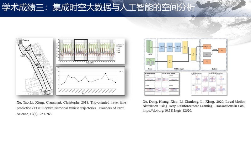
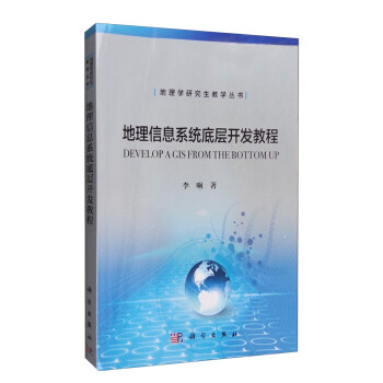
1997 B.Sc. Applying quantitative methods to urban planning, Nanjing University 专著或编著 Books: 李响,2024,地理信息系统底层开发,清华大学出版社 Bertolotto, Michela, Ray, Cyril, Li, Xiang, 2008, Lecture Notes in Computer Science (LNCS) 5373, Springer. Li, Xiang, Bao, Shuming, 2011,Proceedings of 19th International Conference on Geoinformatics, IEEE. Wang, Jun, Ye, Mingwu,Li, Xiang, Xu, Shiyuan, 2013,Risk Evaluation on Natural Hazards in Urban Area and Contingency Methods(in Chinese). Science Press. Li, Xiang, 2016,Develop a GIS from buttom up(in Chinese), Science Press: Beijing, ISBN 978-7-03-049131-2 Li, Xiang, 2017, Modeling and Accessing Trajectory Data of Moving Vehicles, Golden Light Academic Publishing: SaarBrucken, Germany, ISBN 978-3-330-82131-6 Brosset, D., Claramunt, C., Li, X., Wang, T. (Eds.), 2017, Proceedings of 15th International Symposium on W2GIS, Shanghai, China, May 8-9, 2017, Springer. Xiaofeng Meng, Xiang Li, Jianqiu Xu, Xueying Zhang, Yuming Fang, Bolong Zheng, Yafei Li (Eds.), 2023, Spatial Data and Intelligence, Lecture Notes in Computer Science (LNCS) 13887, Springer. 学术论文 Papers: 【2026】 Zhang, D., Mu, S., Mango, J., Li, X.*, 2026, Deep Reinforcement Learning for Spatial ResourceAllocation: A Case Study of School Districting, Environment andPlanning B: Urban Analytics and City Science, 53(2): 418-434. doi: 10.1177/23998083241302187 Xu, Y., Luo, J., Wu, Y., Li, Z., Deng, S., Wang, Y., Jiang, J., Zhao, Q., Butt, K. R., Qiu, J., Li, X.* & Li, Y. (2026). Three-dimensional burrowing behavior of earthworms for ecotoxicological studies. Environmental Science & Technology. https://doi.org/10.1021/acs.est.5c15144 【2025】 Yue, Y., Yan, G., Lan, T. et al. Shaping future sustainable cities with AI-powered urban informatics: Toward human-AI symbiosis. Comput.Urban Sci. 5, 31 (2025). https://doi.org/10.1007/s43762-025-00190-0 【2024】 Zhang, D., Meng, H., Wang, M., Xu, X., Yan, J., Li, X.*, 2024, A Multi-Objective Optimization Method for Shelter Site Selection Based on Deep Reinforcement Learning, Transactions in GIS, 28(8): 2722-2741. doi: 10.1111/tgis.13252 Zhang, D., Wang, M., Mango, J., Li, X.*, Xu, X., 2024, A survey on applications of reinforcement learning in spatial resource allocation. Computational Urban Science. 4, 14. doi: 10.1007/s43762-024-00127-z Zhu, B., Xu, X., Meng, H., Meng, C., Li, X.*, 2024. Applying Segment Anything Model to Ground-Based Video Surveillance for Identifying Aquatic Plant. In: Meng, X., Zhang, X., Guo, D., Hu, D., Zheng, B., Zhang, C. (eds) Spatial Data and Intelligence. SpatialDI 2024. Lecture Notes in Computer Science, vol 14619. Springer, Singapore. doi: 10.1007/978-981-97-2966-1_7 Wang, M., Li, X.*, Tan, K., Mango, J., Pan, C., Zhang, D., 2024, Position-aware graph-CNN fusion network: an integrated approach combining geospatial information and graph attention network for multi-class change detection, IEEE Trans. on Geoscience and Remote Sensing, 62: 1-16, Art no. 4402016, doi: 10.1109/TGRS.2024.3350573. Zhang, Y., Wang, M., Mango, J., Xin, L., Meng, C., Li, X.*, 2024, Individual tree detection and counting based on high-resolution imagery and the canopy height model data, Geo-spatial Information Science, 27(6): 2162–2178. doi: 10.1080/10095020.2023.2299146 【2023】 2023, Temporal-GIS models for cadastral data management: The knowns, unknowns and future, Survey Review, 55:390, 233-246, DOI: 10.1080/00396265.2022.2049104. Huili Jin, Hongwei Xia, Joseph Mango, Jing Wang, Hong Yi, Xiaoming Yu, Xiang Li *, 2023, Investigate the relationship between traumatic occurrences and socio-economic status based on geographic information system, In: Meng, X., et al. Spatial Data and Intelligence. SpatialDI 2023. Lecture Notes in Computer Science, vol 13887. Springer, Cham. https://doi.org/10.1007/978-3-031-32910-4_10 Joseph Mango, Moyang Wang, Senlin Mu, Di Zhang, Jamila Ngondo, Regina Valerian-Peter, Christophe Claramunt and Xiang Li *, 2023, Transform paper-based cadastral data into digital systems using GIS and end-to-end deep learning techniques, International Journal of Geographical Information Science, 37(5): 1099-1127. Joseph Mango, Christophe Claramunt, Xiang Li, Jamila Ngondo, Di Zhang, 2023, Potential Insights on Digital Cadastre for Effective Land Management, Chapter in The International Encyclopedia of Geography: People, the Earth, Environment, and Technology, published by Wiley, in press. Senlin Mu, Xiao Huang, Muyang Wang, Di Zhang, Dong Xu, Xiang Li *, 2023, Optimizing Pedestrian Simulation Based on Expert Trajectory Guidance and Deep Reinforcement Learning, Geoinformatica, https://doi.org/10.1007/s10707-023-00486-5. 【2022】 Joseph Mango, Regina Valerian-Peter, Kennedy Kanja, Jamila Ngondo, Asenath Maobe, Alex Lubida, Ijumulana Julian & Xiang Li (2022) Evaluating the land cover dynamics in the protected areas using GIS and Remote sensing techniques: the case of Nyerere National Park, Tanzania, Geocarto International, 37(27): 17361-17381, DOI: 10.1080/10106049.2022.2127927 Jiabei Luo, Yujie Hu, Keith Davids, Di Zhang, Cade Gouin, Xiang Li *, Xianrui Xu *, 2022, Vision-Based Movement Recognition Reveals Badminton Player Footwork Using Deep Learning and Binocular Positioning, Heliyon, 8(8), e10089. Moyang Wang, Yijun He, Huan Meng, Ye Zhang, Bao Zhu, Joseph Mango, Xiang Li *, Assessing Street Space Quality Using Street View Imagery and Function-Driven Method: The Case of Xiamen, China, 2022, ISPRS International Journal of Geo-Information. 2022; 11(5):282. Yijun He, Xiang Li *, 2022, Comparison of indoor positioning methods based on AR visual and WiFi fingerprinting method, W2GIS, Lecture Notes in Computer Science. 13238: 141-151. (2022) Investigate Job-Home Spatial Relationship with Individual-based Mobility Big Data of Public Housing Tenants: a case study in Chongqing, China, Sustainability, 14, no. 6: 3211. https://doi.org/10.3390/su14063211 Jamila Ngondo, Joseph Mango, Joel Nobert, Alfonse Dubi, Xiang Li, and Heqin Cheng. 2022. Hydrological Response of the Wami–Ruvu Basin to Land-Use and Land-Cover Changes and Its Impacts for the Future, Water 14, no. 2: 184. https://doi.org/10.3390/w14020184 (2022) Multipurpose temporal GIS model for cadastral data management, International Journal of Geographical Information Science, 36(6): 1205-1230, DOI: 10.1080/13658816.2021.2009483 【2021】 Li, Xiang, Mango, Joseph, Song, Jiajia, Zhang, Di (Corresponding author), 2021, XStar: A software system for handling taxi trajectory big data, Computational Urban Science, https://doi.org/10.1007/s43762-021-00015-w Li, Xiang, He, Yijun, 2021, Origin-destination (OD) analysis based on big taxi trajectory data with XStar, In Proceedings of the 29th International Conference on Advances in Geographic Information Systems (SIGSPATIAL '21). Association for Computing Machinery, New York, NY, USA, 159–162. DOI:https://doi.org/10.1145/3474717.3483925 Pengyuan Wang, Xiao Huang, Joseph Mango, Di Zhang, Dong Xu, Xiang Li *(Corresponding author), 2021, A hybrid population prediction approach integrating LSTM and CA models with micro spatio-temporal granularity: A case study of Chongming District, Shanghai, ISPRS International Journal of Geo-Information, 10, 544. https://doi.org/10.3390/ijgi10080544. 朱延冰,罗嘉贝,许涛,徐先瑞,张迪,徐栋,李响. 2021, 基于时空插值的海量车辆轨迹数据索引方法[EB/OL]. 北京:中国科技论文在线 [2021-02-05]. 曹布阳,冯华森,梁峻浩,李响(通讯作者),2021,利用Hilbert曲线与Cassandra技术实现时空大数据存储与索引,武汉大学学报信息科学版,46(5): 620-629 Xu, Dong, Huang, Xiao, Mango, Joseph, Li, Xiang (Corresponding author), Li, Zhenlong (Corresponding author), 2021, Simulating multi-exit evacuation using deep reinforcement learning, Transactions in GIS, 25(3): 1542-1564. 陈渠,徐先瑞,张迪,徐栋,李响(通信作者). 2021, 基于深度学习的多摄像头协同目标跟踪方法研究[EB/OL]. 北京:中国科技论文在线 [2021-01-20]. (2021) Web-based GIS for managing and promoting tourism in sub-Saharan Africa, Current Issues in Tourism, 24(2): 211-227, DOI: 10.1080/13683500.2019.1711028 【2020】 Xu, Dong, Huang, Xiao, Li, Zhenlong, Li, Xiang (Corresponding author), 2020, Local Motion Simulation using Deep Reinforcement Learning, Transactions in GIS, 24: 756-779. Song, Jiajia, Li, Xiang (Corresponding author), Mango, Joseph, 2020, Location Optimization of Urban Emergency Medical Service Stations: A Hierarchical Multi-Objective Model with a New Encoding Method of Genetic Algorithm Solution, Lecture Notes in Computer Science, vol 12473, Springer, doi: 10.1007/978-3-030-60952-8_7. Huang, Jie; Hu, Yujie; Wang, Jiaoe; Li, Xiang, 2020, A tale of two cities: Jobs–housing balance and urban spatial structures from the perspective of transit commuters. Environment and Planning B: Urban Analytics and City Science. July 2020. doi: 10.1177/2399808320938803 【2019】
【2018】 Ye, Jin, Hu, Yujie, Xu, Xianrui, Yi, Hong, Li, Xiang(Corresponding author), 2018, Evaluate Errors of 1-median model: A Case Study in Spring Hill, FL, US, Proceedings of 26th International Conference on Geoinformatics, IEEE, pp.1-4, 24-26 June 2018. Chen, Qu, Yi, Hong, Hu, Yujie, Xu, Xianrui, Li, Xiang(Corresponding author), 2018, A New Method of Selecting K-means Initial Cluster Centers Based on Hotspot Analysis,Proceedings of 26th International Conference on Geoinformatics, IEEE, pp.1-6, 28-30 June 2018. Li, Xiang, Li, Qiuping, Xu, Xianrui, Xu, Dong, Zhang, Xihui. 2018, A novel approach to developing organized multi-speed evacuation plans, Transactions in GIS, 22: 1205-1220. Li, Xiang, Li, Qiuping, Claramunt, Christophe, 2018, A time-extended network model for staged evacuation planning, Safety Science, 108: 225-236. Xu, Tao, Li, Xiang (Corresponding author), Claramunt, Christophe, 2018, Trip-oriented travel time prediction (TOTTP) with historical vehicle trajectories, Frontiers of Earth Science, 12(2): 253-263. Xu, Tao, Zhang, Xihui, Claramunt, Christophe, Li, Xiang(Corresponding author), 2018,TripCube: A Trip-Oriented Vehicle Trajectory Data Indexing Structure, Computers, Environment and Urban Systems, 67: 21-28. 【2017】 Xu, Dong, Li, Xiang(Corresponding author), 2017, A time-extended network approach to planning multi-velocity evacuation, Complex Systems and Complexity Science, 14(1): 88-95. (徐栋,李响,2017,基于时间扩展网络制定的混合速度疏散算法,复杂系统与复杂性科学,14(1): 88-95) Zheng, Yi, Yang, Tingting, Xu, Dong, Xu, Tao, Li, Xiang(Corresponding author), 2017, Coordinating Multiple Cameras to Assist Tracking Moving Objects Based on Network Topological Structure, Geomatics and Information Science of Wuhan University, 42(8): 1117-1122. (郑毅,杨婷婷,徐栋,许涛,李响,2017,基于网络拓扑结构的多摄像头移动对象辅助协同跟踪,武汉大学学报信息科学版,42 (8): 1117-1122)
郑毅,陈林,徐栋,徐先瑞,李响 (通信作者). 2017. 复杂场景中的运动目标检测研究[EB/OL].北京:中国科技论文在线 [2017-05-03]. Xu, Tao, Xu, Xianrui, Hu, Yujie, Li, Xiang(Corresponding author), 2017, An entropy-based approach for evaluating travel time predictabilitybased on vehicle trajectory data, Entropy, 19(4): 165.
Xu, Yuanyuan, Ta, Na,Li, Xiang, 2017, Analysis of Communicating Behavior and Employment Center Using Smart Card Data, Human Geography, 155(3): 93-101. (许园园,塔娜,李响,2017,基于地铁刷卡数据的城市通勤与就业中心吸引范围研究,人文地理,155(3): 93-101) Ren, Huijun, Chai, Peishan, Zhang, Yanbing, Xu, Dong, Xu, Tao, Li, Xiang (Corresponding author), 2017, Semiautomatic Indoor Positioning and Navigation with Mobile Devices, Annals of GIS, 23(1): 15-26.
柴培汕, 李响, 2016, 基于移动设备的室内定位导航, 第六届高校GIS论坛论文集(优秀论文), 上海
Yang, Tingting,Li, Xiang, 2016,The accuracy assessment of real-time road status system based on multi-original data, Journal of Jiangsu Normal University (Natural Science Edition), 34(3): 65-69 (杨婷婷,李响,2016,基于众源数据的实时路况发布系统准确性的评估,江苏师范大学学报(自然科学版),34(3):65-69) 【2015】 Xu, Tao, Wang, Jionghua,Li, Xiang, 2015,A fast image rectification method for video captured with UAV hovering over traffic intersections, Annals of GIS, 21(1): 43-53. Wang, Jionghua, Xu, Tao,Li, Xiang(Corresponding author), 2015,Geometric Correction for Images of Intersection Taken by Hovering UAV, Geomatics and Information Science of Wuhan University,40(6): 738-743. Li, Xiang, Xu, Xianrui, Yi, Hong, 2015,Delineating service area of capacitated public facilities——A case study of shelters in Shanghai(in Chinese with English abstract),City Planning Review, 39(1). Xie, Jun, Wan, Qing, Zhang, Chi,Li, Xiang(Corresponding author), 2015,Comparison of two approaches for evacuation plan with multiple exits, Chapter 25, Building Resilient Cities in China: The Nexus between Planning and Science, GeoJournal Library, Vol. 113, Springer. 【2014】 Hu, Yujie, Miller, Harvey,Li, Xiang, 2015,Detecting and analyzing mobility hotspots using surface networks, Transactions in GIS, 18(6): 911-935. Luo, Feixiong, Cao, Guofeng,Li, Xiang, 2014,An interactive approach for deriving geometric network models in 3D indoor environments, Proceedings of ACM SIGSpatial workshop on ISA 2014, November 4-7, 2014, Dallas, TX, USA. Ren, Huijun, Xu, Tao,Li, Xiang(Corresponding author), 2014,Driving behavior analysis based on trajectory data collected with vehicle-mounted GPS receivers, Geomatics and Information Science of Wuhan University, 39(6): 739-744. Xie, Jun, Zhang, Chi, Wan, Qing, Li, Qiang,Li, Xiang(Corresponding author), 2014,Near optimal allocation strategy for making a staged evacuation plan with multiple exits, Annals of GIS, 20(3): 159-168. Xie, Jun, Wan, Qing, Zhang, Chi, Li, Qiang,Li, Xiang(Corresponding author), 2014,Applicability analysis for virtual node method applied in multiple exits evacuation planning (in Chinese with English abstract), Computer Engineering and Application, 50(23): 245-250. 【2013】 Li, Xiang, Hu, Yujie, Xie, Jun, Sun, Jing, 2013,An efficient approach to building image-based road network model,Annals of GIS, 19(4): 209-217. Chi, Guanghua, Xie, Jun, Li, Qiang, Yang, Liao,Li, Xiang(Corresponding author), 2013,A method for planning multilayer and multi-exit indoor emergency evacuation(in Chinese with English abstract), Remote Sensing Information, 28(6): 116-120. Zhao, Minyue,Li, Xiang(Corresponding author), 2013,Deriving Average Delay of Traffic Flow around Intersections from Vehicle Trajectory Data, Frontiers of Earth Science, 7(1): 28-33. Jiang, Yijuan,Li, Xiang(Corresponding author), 2013,Travel time prediction based on historical trajectory data, Annals of GIS, 19(1): 27-35. 【2012】 Sun, Jing, Li, Xiang(Corresponding author), 2012,A Pyramid-based approach to visual exploration of a large volume of vehicle trajectory data, Frontiers of Earth Science, 6(4): 345–353. Jiang, Yijuan, Li, Xiang, Li, Xiaojie, Sun, Jing, 2012,Extracting geometrical features of road network and accuracy analysis with vehicle trajectory data(Chinese with English abstract), Journal of Geo-information Science, 14(2): 165-170. Li, Xiang, Huang, Bo, Liu, Zhengjun, Zhang, Xihui, Sun, Jing, 2012,A novel method for planning a staged evacuation, Journal of Systems Science and Complexity, 25(6): 1093-1107. Li, Xiang, Claramunt, Christophe, Zhang, Xihui, Huang, Yingping, 2012,A fast and deterministic approach to a near optimal solution for the p-median problem, International Journal of Operations Research and Information Systems, 3(3): 1-14. 【2011】 Sun, Jing,Li, Xiang(Corresponding author), 2011,Indoor evacuation routes planning with a grid graph-based model, Proceedings of19th International Conference on Geoinformatics, IEEE, pp.1-4, 24-26 June 2011. Zhao, Minyue,Li, Xiang(Corresponding author), 2011,An application of spatial decision tree for classification of air pollution index, Proceedings of19th International Conference on Geoinformatics, IEEE, pp.1-6, 24-26 June 2011. Hu, Yujie,Li, Xiang(Corresponding author), 2011,A novel approach to extracting street lamps from vehicle-borne laser data, Proceedings of19th International Conference on Geoinformatics, IEEE, pp.1-6, 24-26 June 2011. Li, Xiang, Ningchuan, Xiao, Claramunt, Christophe, Hui Lin, 2011,Initialization strategies to enhancing the performance of genetic algorithms for the p-median problem, Computers & Industrial Engineering, 61(4): 1024-1034. Xu, Xianrui,Li, Xiang(Corresponding author), Li, Xiaojie, 2011,An improved scatter search algorithm for capacitated p-Median problem(in Chinese with English abstract), Computer Engineering and Application, 47(20): 28-30. Huang, Yiyu,Li, Xiang(Corresponding author), 2011,Preliminary exploration on scenario-based contingency planning(in Chinese with English abstract), Safety and Environmental Engineering, 2011(2): 56-59. Zhang, Xihui, Huang, Yingping, Crabtree, John,Li, Xiang, 2011,A survey of channel allocation algorithms for wireless local loops. Information Technology Journal, 10(2): 231-238. Li, Xiang, Sun, Jing, Zhao Minyue, Xie, Jun, 2011,A novel model for the analysis of indoor spaces, (in Chinese with English abstract), Sciencepaper Online. Li, Menglei,Li, Xiang, 2011,Find the shortest path with A* Algorithm in an Indoor Space, (in Chinese with English abstract), Sciencepaper Online. 【2010】 Li, Xiaojie,Li, Xiang(Corresponding author), 2010,Preliminary application of gesture recognition to virtual geographical environment(in Chinese with English abstract), Geomatics & Spatial Information Technology, 33(5): 41-44. Huang, Yiyu, Su, Wenjing,Li, Xiang(Corresponding author), 2010,Comparison of BEKK GARCH and DCC GARCH models: An empirical study, Lecture Notes in Computer Science, 6441: 99-110. Xiao, Sen,Li, Xiang, 2010,Geographical information system research and applications in indoor space(in Chinese with English abstract), Geomatics & Spatial Information Technology, 33(5): 38-40. Li, Xiaojie,Li, Xiang(Corresponding author), Tang, Daimin, and Xu, Xianrui, 2010,Deriving features of traffic flow around an intersection from trajectories of vehicles, Proceedings of18th International Conference on Geoinformatics, IEEE, pp.1-5, 18-20 June 2010. Li, Xiang, Claramunt, Christophe, Cyril, Ray,A grid graph-based model for the analysis of 2D indoor spaces, Computers, Environment and Urban Systems, 34(6): 532-540. Hu, Yujie,Li, Xiang(Corresponding author), 2010,Find a center’s service area of a geographic network by the shortest path algorithm(in Chinese with English abstract), Geography and Geo-Information Science, 26(3): 111-112. Zhang, Xihui, Hu, Tao, Dai, Hua, andLi, Xiang, 2010,Software development methodologies, trends and implications: A testing centric view. Information Technology Journal, 9(8): 1747-1753. Yi, Hong,Li, Xiang(Corresponding author), 2010,Analysis on the intraurban distribution of business services in Guangzhou in the transit era(in Chinese with English abstract), Modern Urban Research, 25(7): 47-52. Hu, Yujie,Li, Xiang(Corresponding author), Li, Menglei, 2010,A novel approach to delineating the service area of facilities in a network, Proceedings of the 2010 International Conference on Future Computer and Communication, IEEE, vol. 2, pp. 35-39. Tang, Daimin,Li, Xiang(Corresponding author), Jiang, Yijuan, 2010,Microscopic traffic simulation oriented road network data model, Proceedings of the 2010 International Conference on Future Computer and Communication, IEEE, vol. 2, pp. 87-91. Zheng, Yanfei,Li, Xiang(Corresponding author), Li, Menglei, Li, Xiaojie,Tang, Daimin, 2010,Modeling road surface and network froma 3D perspective, Proceedings of the 2nd International Conference on Computer Engineering and Technology, IEEE, vol. 2, pp. 186-190. Xu, Xianrui,Li, Xiang(Corresponding author), Li, Xiaojie, 2010,An improved scatter search algorithm for capacitated p-Median problem, Proceedings of the 2nd International Conference on Computer Engineering and Technology, IEEE, vol. 2, pp. 316-320. 【2009】 Xiao, Sen,Li, Xiang, 2009,A method of information transmission based on limited information flow in location based services(in Chinese with English abstract), Sciencepaper Online. Zheng, Yanfei,Li, Xiang(Corresponding author), Lin, Hui, Li, Menglei, Li Xiaojie, 2009, A new approach to the generation of 3D road surface model,Proceeding of International Workshop on GIS for Transportation, Dec. 4-6, 2009, Wuhan, China, pp. 176-180. Li, Xiang, Claramunt, Christophe, Cyril, Ray, 2009,A continuous-based model for the analysis of indoor spaces, Proceedings of Workshop on Spatial and Temporal Reasoning for Ambient Intelligence Systems, Conference on Spatial Information Theory (COSIT 2009), Sep. 21, 2009, Aber Wrac'h, France, pp. 44-53. Li, Xiang, Liu, Zhengjun, Zhang, Xihui, 2009,Applying genetic algorithm and hilbert curve to capacitated location allocation of facilities, Proceedings of the 2009 International Conference on Artificial Intelligence and Computational Intelligence, Nov. 7-8, 2009, Shanghai, China, IEEE, vol 1, pp. 378-383. Li, Xiang, Liu, Zhengjun, Lin, Hui, Zhang, Xihui, 2009,Connectivity-oriented vehicle trajectory data query(in Chinese with English abstract), Journal of Image and Graphics, 14(7):1245-1250. Li, Xiang, Zhang Xihui, Lin, Hui, 2009,Deriving network-constrained trajectories from sporadic tracking points collected in location-based services, Geo-spatial Information Science, 12(2): 85-94. Zheng, Yanfei,Li, Xiang(Corresponding author), 2009,A novel algorithm for planning an organized evacuation(in Chinese with English abstract), Journal of East China Normal University, 2009(5): 45-52. Zhang, Xiaoyi, Zhang Yanping,Li, Xiang(Corresponding author), Tang, Daimin, 2009,Spatio-temporal condition of network-constrained trajectories—taking the extraction of traffic flow for example(in Chinese with English abstract), Journal of Transportation Information and Safety, 27(5): 44-47. Bertolotto, Michela, Ray, Cyril,Li, Xiang, 2008,Editorial: Preface of web and wireless GIS, Lecture Notes in Computer Science (LNCS) 5373, Springer. 【2008】 Li, Xiang,Lin, Hui, Guo, Zhongyang, Zhang, Xihui, 2008,Reducing vehicle tracking data volume through a network-based approach,Acta Geodaetica et Cartographica Sinica, 37(1) 95-101. Li, Xiang,Claramunt, Christophe, Kung, Hiang-te, Guo, Zhongyang, Wu, Jianping, 2008,A decentralised and continuity-based algorithm for delineating capacitated shelters' service areas,Environment and Planning B:Planning and Design, 35(4) 593- 608. Li, Xiang, Shu, Jiong, Liu, Zhengjun, 2008,Applying GIS to video surveillance in indoor space,Journal of Remote Sensing,12(5) 55-60. (in Chinese with English abstract) 【2007】 Li, Xiang, Zhang, Xihui., Tan, Lu, 2007,Assisting video surveillance in micro-spatial environments with a GIS approach, Proceedings ofGeoinformatics 2007, May 26-27, Nanjing, China. Zhang, Xihui, Li, Yulong,Li, Xiang, Liu, Yuxiang, and Tan, Lu, 2007,GIS-based earthquake hazard assessment of urban power systems - Memphis electric substations, Proceedings ofGeoinformatics 2007, May 26-27, Nanjing, China. 【2006】 Li, Xiang, Claramunt, Christophe, Ray, Cyril, Lin, Hui:A semantic-based approach to the representation of network-constrained trajectory data, Proceedings of the 12th International Symposium on Spatial Data Handling (SDH 2006), pp. 451-464, W. Kainz, A. Reidl, and G. Elmes (eds.), Vienna, Austria, Springer-Verlag, July 2006, ISBN 3-540-35588-x Li, Xiang, 2006,A fast map matching algorithm for low-frequency vehicle tracking data,Proceedings of The 6th International Conference of Transportation Professionals, June 23-25, 2006, Dalian, China. Li, Xiangand Lin, Hui, 2006,A trajectory-oriented, carriageway-based road network data model, part 3: Implementation,Geo-spatial Information Science, 9(3) 201-205. Li, Xiangand Lin, Hui, 2006,A trajectory-oriented, carriageway-based road network data model, part 2: Methodology,Geo-spatial Information Science, 9(2) 112-117. Li, Xiangand Lin, Hui, 2006,A trajectory-oriented, carriageway-based road network data model, part 1: Background,Geo-spatial Information Science, 9(1) 65-70. Li, Xiangand Claramunt, Christophe, 2006,A spatial entropy-based decision tree for classification of geographical information,Transactions in GIS, 10(3) 451-467. Li, Xiangand Lin, Hui, 2006,Indexing network-constrained trajectories for connectivity-based queries,International Journal of Geographical Information Science, 20(3): 303-328. 【2005】 Claramunt, C., Fournier, S.,Li, Xiang., and Peytchev, E., 2005, Real-time geographical information systems for ITS,Proceedings of The 5th International Conference on ITS Telecommunications, June 27-29, 2005, Brest, France, pp. 237-242. Li, Xiangand Lin, Hui, 2005, A preliminary framework for cooperative traffic data applications,Proceedings of The 5th International Conference of Transportation Professionals, June 25-26, 2005, Xi'an, China, Beijing: China Communication Press, pp. 22-28. Li, Xiang, 2005, A novel method of indexing trajectory data of objects moving in a network,Proceedings of the 101th Annual Meeting of the AAG, April 5-9, 2005, Denver, US. Li, Xiang, Lin, Hui, and Zhao, Yibin, 2005, A connectivity-based map matching algorithm,Asian Journal of Geoinformatics, 5(3): 69-76. 【2004】 Li, Xiangand Lin, Hui, 2004, Modeling trajectory data of moving vehicles as mobile sensors for traffic study,Proceedings of the 4th International Symposium on Mobile Mapping Technology, March 29-31, 2004, Kunming, China. Li, Xiang, Lin, Hui, and Shen, Dayong, 2004, An LRS-based data model for moving vehicles, (in Chinese),Proceedings of The 4th International Conference of Chinese Transportation Professionals, June 15-20, 2004, Wuhan, China. Li, Xiang,Lin, Hui, and Shen, Dayong, 2004, Modeling trajectory data in Cooperative Intelligent Transportation Systems (CITS) (in Chinese),Computer and Communications, 22(4): 6-9. 【2003】 Li, Xiang, Lin, Hui,and Shen, Dayong, 2003, An GIS-T-based data model for moving vehicles, (in Chinese),Proceedings of Urban Geographical Information System Forum, ?November 29-30, 2003, Shenzhen, China. Li, Xiangand Lin, Hui, 2003, A lane-Specific, temporal GIS-T data model for mobile object in dynamic road network,Proceedings of the 3rd International Symposium on Digital Earth, pp. 459-471, September 21-25, 2003, Brno, Czech republic. 【2002】 Li, Xiangand Lin, Hui, 2002, Participatory comprehensive plan based on Virtual Geographical Environment,Proceedings of the 23rd Asian Conference on Remote Sensing (ACRS), November 25-29, 2002, Katmandu, Nepal. 【2001】 Wang, Zhibing, Li, Manchun,Li, Xiang, and Yu, Qian, 2001, Developing WebGIS based on internet map server (in Chinese),Remote Sensing Information, 2001(3): 120-121. Yu, Qian, Wu, Guoping,Li, Xiang, et al., 2001, Storing spatial data into relational database (in Chinese),Remote Sensing Information, 2001(1): 26-30. Li, Xiang and Lin, Hui, 2001, Digital urban planning based on Virtual Geographical Environment (VGE) (in Chinese),Proceedings of Urban Geographical Information System Forum, pp. 29-36, September 17-20, 2001, Guangzhou, China. 【2000】 Li, Manchun, Chen, Qi, Zhou, Yankun, andLi, Xiang, 2000, Data organizing and processing of enterprise GIS based on spatial data engine (in Chinese),Journal of Image and Graphics, 5[A](3): 179-185. 【1999】 Li, Xiang, 1999, A shortest path algorithm for transportation facilities between cities (in Chinese),City, 1999(3): 51-52. Li, Xiang, Li, Manchun, Yi, Hong, et al., 1999, The research of multithreads of synchronizing control in JAVA under modern operate system (in Chinese),Computer Application Research, 1999(4): 14-16. Li, Xiangand Yi, Hong, 1999, Rapid implementation of OLE automation technique and map windows (in Chinese),Computer Study, 1999(4): 33-34. Li, Xiang and Li, Manchun, 1999, A fundamental study on application and practice of integrating database of GIS with object-oriented database technology (in Chinese),Geo-information Science, 1999(1): 26-32. Li, Xiang, Li, Manchun, Yu, Yousheng, and Yi, Hong, 1999, A GIS data model for underground pipe network in urban area (in Chinese),Remote Sensing Information, 1999(3): 15-18. Li, Xiang and Yu, Yousheng, 1999, The global information revolution and Digital Earth (in Chinese),China Information Review, 1999(9): 36-37. Li, Manchun,Li, Xiang, Chen, Gang, et al., 1999, About digital earth (in Chinese),Modern Surveying and Mapping, 1999(2): 5-8. Yu, Yousheng, Li, Manchun, Wu, Guoping,Li, Xiang, and Chen, Gang, 1999, Designing and developing landuse planning management information system in county based on client/server architecture (in Chinese),Remote Sensing Information, 1999(4): 29-32. 【1998】 Yi, Hong andLi, Xiang, 1998, Application of principal-component analysis in urban system planning (in Chinese),Jiangsu Urban Planning, 1998(3). 会议及受邀报告 Conferences and Invited Presentations: 2023年12月8日,上海,焕庸大讲堂,时空大数据助力人文地理学研究 2023年12月2日, 北京,ACM Sigspatial 战略研讨会,深度强化学习在空间优化中的应用探索 2023年10月30日,江西师范大学,空间计算与城市资源优化配置研讨会,深度强化学习在空间优化中的应用探索 2023年9月23日,上海,第二届从红外到太赫兹国际会议(ESIT 2023),从空间视角看人工智能在数字社会建设中的应用实践 2023年7月1日,华东师范大学,地缘环境跨学科创新团队论坛,地理信息科学与地缘环境 2023年6月30日,上海外国语大学,地理学与区域国别研究论坛,基于时空大数据的空间优化技术在区域研究中的应用探索 2023年6月21日,华东师范大学设计学院,交叉学科论坛,地理信息系统与人工智能 2023年5月18日,上海晋元中学,地理信息科学、人工智能与应用 2023年4月19日,上海,火山引擎Force 2023原动力大会,从空间视角看人工智能在数字社会建设中的应用实践 2023年4月14日,江西财经大学,SpatialDI 2023,Investigate the relationship between traumatic occurrences and socio-economic status based on geographic information system (GIS): The Case of Qingpu in Shanghai, China,海报,(金慧丽等) 2020年10月16日,华东师范大学地理科学学院2020级拔尖班,地理信息系统、空间优化与大数据 2020年9月8日,上海交通大学设计学院,地理信息系统、空间优化与大数据 2020年1月8日,深圳大学城市空间信息工程系,From GIS to Anywhere 2019年12月10日,东南大学交通学院,空间优化、大数据及其在物流管理中的应用 2019年7月11日,全国青少年高校科学营华东师范大学分营,地理信息系统与大数据 2019年7月6日,华东师范大学地理科学实践工作站,地理信息系统与大数据 2019年7月5日,河海大学【2019年全国高校青年教师GIS教学培训班】,地理信息系统底层开发教学实践 2019年1月23日,深圳大学城市空间信息工程系,空间优化、大数据及其在智慧城市中的应用 2018年12月2日,长沙【第12届资源学院院长论坛】,空间资源优化与大数据时代下的挑战 2018年10月18日,华东师范大学【‘From smart and eco to smart eco-cities’ Summer School 2017 in Shanghai 2018】,Spatial optimization facilitating urban planning and management 2018年10月17日,华东师范大学【‘From smart and eco to smart eco-cities’ Summer School 2017 in Shanghai 2018】,Spatial optimization and big data in urban area 2018年7月8日,兰州交通大学【第六届全国测绘地理信息青年学者论坛】,时空大数据索引技术及应用实践 2018年7月6日,上海财经大学【中国城市与区域实验室(CCRL)年会】,空间优化与大数据 2018年4月21日,同济大学【上海城市规划大数据春季研讨会】,时空轨迹大数据索引方法及工具实践 2018年1月13日,武汉大学【第五届空间信息智能服务研讨会】,时空大数据索引方法研究 2017年4月24日,香港中文大学,Spatial operational research and its application in emergency services
A scheduling algorithm for making an evacuation plan,May 25, 2016,International Workshop on Advanced Geospatial Technology and Urban Applications, The Chinese University of Hong Kong, Hong Kong, China A two-step approach to planning new facilities towards equal accessibility, Dec. 11, 2015, The 11th Workshop on Spatial Behavior Research and Planning: Spatial-temporal Behavior Theory and Application Frontiers, Sun Yat-Sen University, China Key technologies of big data process and analysis, Nov. 21, 2015, Department of Urban Planning, Tongji University, China Spatial operational research ang its application, Feb. 13, 2015, Department of Geography, Ohio State University, USA How to make an evacuation plan? A GIS approach, Jan. 28, 2015, Department of GIS, University of Texas at Dallas, USA GIScience and its applications, Mar. 25, 2014, Software School, East China Normal University, Shanghai, China GIScience and its applications in ITS, Annual Meeting of China Geographic Society (East China) 2013, Nov. 2, 2013, Fujian Normal University, Fujian, China An efficient approach to building image-based road network model, Geoinformatics 2012, Jun. 17, 2012, The Chinese University of Hong Kong, Hong Kong, China Applying GIScience to transportation, Oct. 24, 2012, East China Normal University, Shanghai, China GIScience and its applications, April 20, 2012, Nanjing University (Jinling College), Nanjing, China GIScience and its applications, April 9, 2012, Shanghai University, Shanghai, China GISystem or GIScience? May 13, 2011, Jimei University, Xiamen, China A spatial entropy-based decision tree for classification of geographical information, Nov. 25, 2010, Xiamen University, Xiamen, China Genetic algorithms for p-median problem, Dec. 20, 2009, Tongji University, Shanghai, China A novel method of planning a staged evacuation,CPGIS Young Scholar Summer Workshop, Jun. 19, 2008, East China Normal University, Shanghai, China Key techniques of applying GIS to emergency services,Graduate student seminar, Dec. 11, 2007, State Key Laboratory of Estuarine and Coastal Research, Shanghai, China Key techniques of applying GIS to emergency services, Nov. 30, 2007, Chinese Academy of Surveying and Mapping, Beijing, China Applying GIS to emergency services,seminar of ISEIS, Sep. 14, 2007, The Chinese University of Hong Kong, Hong Kong An novel algorithm to delineating service areas of shelters,10th Anniversary workshop of JLGIS, Aug. 28, 2007, The Chinese University of Hong Kong, Hong Kong Deriving network-constrained trajectories from sporadic tracking points collected in LBS, in proceedings ofThe First Symposium of GIS-T in China, Jun. 25, 2007, Wuhan, China. GIS-based vulnerability analysis of floods, Hydrological Sciences for Managing Water Resources in the Asian Developing World,Jun. 9, 2006, Guangzhou, China. Applying genetic algorithms to the location allocation of shelter sites,102th Annual Meeting of the AAG, Mar. 7-11, 2006, Chicago, IL. A presentation on China,Course of World Geography, Nov. 3, 2005, The University of Memphis, Memphis, TN, US.
林珲教授,香港中文大学,江西师范大学 李满春教授,南京大学 Dr. Christophe Claramunt, Professor and Director, Naval Academy Research Institute Lanveoc-Poulmic, Brest Naval, France Dr. Hsiang-te Kung The University of Memphis, Memphis, Tennessee, US 荣誉及奖励2025:所指导学生孟焕、丁严、肖南宇获“智能与协同·2025第十三届高校GIS论坛”“创新创业大赛”一等奖 2025:所指导学生丁严获2025—2026年度上海发展研究奖学金(华东师范大学唯一一人) 2025:指导上海中学国际部学生获“上中科技周”学术先锋决赛第一名 2025:所指导学生吴雨嫣、朱晓蕴、方天垚获第五届美团商业分析精英大赛全国第二名(out of 1206) 2024:获华东师范大学研究生教育卓越育人奖 2024:所指导学生李政辉获中国研究生智慧城市创新技术与创意设计大赛三等奖 2024:所指导学生徐同军、孔莞悦、叶灿灿入围全国挑战杯揭榜挂帅决赛 2024:所指导学生方天垚、吴雨嫣、朱晓蕴获第二十一届中国研究生数学建模竞赛二等奖 2024:所指导学生何益郡获上海市优秀毕业生 2024:所指导学生何益郡获华东师范大学2024年优秀硕士论文 2024:所指导学生王默杨获华东师范大学国家奖学金 2024:获2024年空天信息技术大会空天信息科技期刊先进审稿人奖 2024:指导中学生获第39届上海市青少年科技创新大赛二等奖(与施程成老师共同指导) 2024:所指导学生胡潇洋、吕云蕾、石佳获“大夏杯”大学生课外学术科技作品竞赛二等奖 2024:湖北省科学技术奖二等奖,复杂时空数据环境下数智孪生关键技术及应用,个人排名第四,单位排名第三 2024:所指导学生胡潇洋、吕云蕾、石佳获中国大学生计算机设计大赛二等奖(与钱冬明老师共同指导) 2024:民进上海市委参政议政一等奖(共同参与) 2024:所指导学生胡潇洋、石佳、吕云蕾获上海市大学生计算机应用能力大赛(信息可视化设计)二等奖(与钱冬明老师共同指导) 2024:所指导学生薛玮丞、钟立、黄小航获上海市大学生计算机应用能力大赛(信息可视化设计)三等奖 2024:所指导学生孟焕,徐同军,孔菀悦,叶灿灿,在2024浦源大模型挑战赛中,入围50强名单。 2023:指导中学生获第38届上海市青少年科技创新大赛二等奖(与施程成老师共同指导) 2023:所指导学生车兴批等获第七届上海市工程管理创新大赛三等奖(与阮光册、许忠好老师共同指导) 2023:所指导学生王默杨、张叶获华东师范大学优秀学生奖 2023:获华东师范大学统一战线新进个人奖 2023:所指导学生徐同军等获华为杯第二十届中国研究生数学建模竞赛三等奖 2023:所指导学生孟焕等获2023年度挑战杯国家级竞赛一等奖 2023:所指导学生金慧丽等获第四届中国空间数据智能大会(SpatialDI 2023)最佳论文奖 2023:所指导学生罗嘉贝获磐石奖学金 2022:所指导学生张叶获华为杯第十九届中国研究生数学建模竞赛二等奖 2022:所指导学生李政辉等获华为杯第十九届中国研究生数学建模竞赛三等奖 2022:所指导学生朱宝等获华为杯第十九届中国研究生数学建模竞赛三等奖 2022:所指导学生管梅哲等获上海市挑战杯大学生科创大赛铜奖 2021:所指导学生张迪等获华为杯第十八届中国研究生数学建模竞赛三等奖 2021:所指导学生木森林获华为杯第十八届中国研究生数学建模竞赛二等奖 2021:所指导学生朱轶杰、樊群渤、管梅哲 、张舒淇、刘畅获华东师范大学第七届本科生创新创业训练学术论坛最佳报告 2021:所指导学生王默杨、朱宝、张叶、何益珺、孟焕获厦门大数据安全开放创新应用大赛·资源规划专题二等奖 2020:所指导学生罗嘉贝、徐栋获华为杯第十七届中国研究生数学建模竞赛二等奖 2020:所指导学生金慧丽获华为杯第十七届中国研究生数学建模竞赛二等奖 2020: 所指导学生何益珺、刘泽平、樊春英获2020年(第十二届)上海市大学生计算机应用能力大赛类一等奖,GeoSpatial选址系统 2020: 所指导学生何益珺、刘泽平、樊春英获2020年(第十三届)中国大学生计算机设计大赛,软件应用与开发-算法设计与应用类三等奖,GeoSpatial选址系统 2020: 所指导学生何益珺、刘泽平、樊春英获2020年(第六届)中国国际“互联网+”大学生创新创业大赛华东师范大学校赛优胜奖,GeoSpatial选址系统 2020: 所指导学生何益珺、刘泽平、樊春英获2020年华东师范大学本科生计算机应用能力大赛二等奖,GeoSpatial选址系统 2019: An Iterative Two-Step Approach to Area Delineation 获W2GIS2019最佳论文奖,Li X., Chen Q., Cao B., Claramunt C., Yi H. 2018: 所指导学生宋嘉佳、王鹏远、朱延冰获全国研究生数学建模大赛,三等奖 2018: 所指导学生朱延冰、陈渠、叶金获普适导航杯时空轨迹大数据应用大赛第一名 2017: 获2017年华东师范大学-航天宏图杯PIE遥感图像处理软件二次开发大赛优秀指导教师奖 2017: 所指导学生朱延冰、石艳、叶金、陈渠,获2017年华东师范大学-航天宏图杯PIE遥感图像处理软件二次开发大赛一等奖,作品名称:趣味地理轻松学——在哪儿视频播放器 2017: 所指导学生朱延冰及其他两位同学获全国研究生数学建模大赛,二等奖 2017: 所指导学生石艳、叶金、陈渠获全国研究生数学建模大赛,三等奖 2017: 所指导学生张砚炳、朱延冰及其他两位同学,荣获华为杯研究生电子设计大赛,上海赛区三等奖,作品名称:以驾驶行为分析为目的的多元轨迹信息融合及应用前景探究 2016: 所指导学生张砚炳及其他两位同学,荣获华为杯研究生电子设计大赛,全国三等奖,作品名称:基于uwb室内定位研究 2016: 所指导学生朱延冰、石艳、陈林、许园园,获第二届全国研究生移动终端应用设计创新大赛,三等奖,作品名称:我家农场 2016: 获2016年全国移动互联网创新大赛高校组教学成果,二等奖(两项) 2016: 柴培汕、李响,获第六届高校GIS论坛优秀论文,论文:基于移动设备的室内定位导航 2016: Supervisor of XUE Rui, who developed an Android-based system and won the third place in the first Hui Chuang QIng Chun Shanghai Collage Student Contest on Creative Design (薛蕊:2016年第一届“汇创青春”上海大学生文化创意作品赛,三等奖) 2015: Supervisor of XUE Rui, who developed an Android-based system and won the third place in the second National Graduate Contest on Smart-City and Creative Design (薛蕊:2015年第二届全国研究生智慧城市技术与创新设计大赛,创意设计赛,三等奖) 2015: Supervisor of REN Huijun, ZHENG Yi, YANG Tingting, XU Dong, who developed an Android-based indoor positioning and tracking system and won the third place inChina Graduate Contest on Application, Design and Innovation of Mobile-Terminal 2014: The first place (With Dr. WANG Jun, Dr. YE Mingwu, and Dr. XU Shiyuan), Shanghai Scocial Science Publication,Risk Evaluation on Natural Hazards in Urban Area and Contingency Methods 2014: Supervisor of XU Dong, XIE Jun, REN Huijun, ZHENG Yi, YANG Tingting, who won three excellence awards in the firstNational Graduate Contest on Smart-City Technology and Creative Design 2014: Supervisor of XU Tao, who won the second place in student paper competition, Geoinformatics 2014, Kaohsiung, Taiwan 2013: Supervisor of XIE Jun, who wonthe first place in student paper competition, Geoinformatics 2013, Kaifeng 2012: Supervisor of JIANG Yijuan, who wonthe first place in student paper competition, Geoinformatics 2012, Hong Kong 2011: Academic Star Award for Junior Faculty Member, East China Normal University, China 2010: Excellent Instructors Award for Innovative Practices in Teaching, East China Normal University, China 2005:The second place in GIS Specialty Group student paper competition, AAG 2005, Denver, US 2005: Postdoctoral fellowship, Naval Academy Research Institute, France 2003&2004: Postgraduate Student Grants for Overseas Academic Activities, The Chinese University of Hong Kong, Hong Kong 2001-2004: Postgraduate Studentship, The Chinese University of Hong Kong, Hong Kong 2003: Nomination of the best postgraduate research output award, Dept. of Geography and Resource Management, The Chinese University of Hong Kong, Hong Kong 1999: Chinese Science Academy Scholarship, China 1999: Certificate for Software Engineer, China 1995: People's Fellowship, Nanjing University, China 1994: People's Fellowship, Nanjing University, China |